In the early ninth century, the Bulgar khan Krum waged a relentless war against the Romans, killed the emperor, and besieged Constantinople. Yet he died suddenly while camped outside the city, and his son and successor Omurtag negotiated a pact with the Romans to end hostilities and consolidate his father’s gains.
The map below shows the Balkans in 816 CE following the conclusion of the thirty-year peace between the Bulgars and Romans.
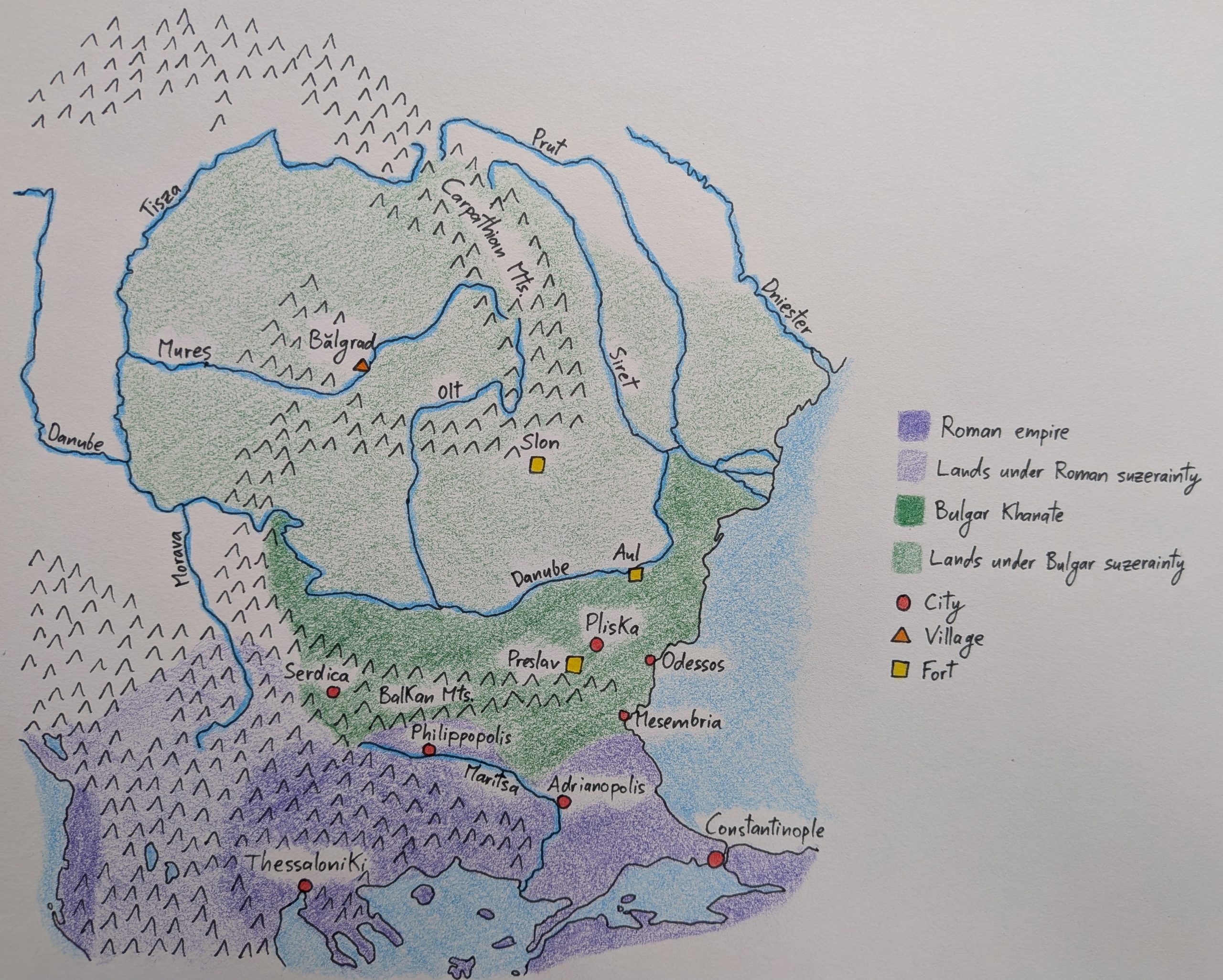
In terms of territory, the Bulgars gained the cities of Odessos and Mesembria on the Black Sea coast, as well as that of Serdica in the Balkan Mountains. To more clearly see their gains, you can compare this map with the previous one showing the khanate in 805.
The treaty of 816 stipulated that, at some point in the future, the Romans were to hand over the city of Philippopolis and its environs to the Bulgars, though we don’t know after how many years. To ensure the Romans upheld their promise, the Bulgars maintained garrisons near Adrianopolis, which were to leave only when the transfer was completed.
The Bulgar khan Omurtag secured his frontier with the Roman empire by building a long fortification running from the Black Sea to the Maritsa River, consisting of a trench and earthen wall punctuated by wooden and stone structures. He also built a fort south of Pliska, called Preslav by the Slavs, to stop any future Roman advance on the capital.
To the north of Pliska, Omurtag built another fort at a crossing on the Danube to defend against incursions from steppe raiders—such as the Magyars who lived beyond the Dniester River. We don’t know what the Bulgars nor the Slavs called this fort, so I’ve labelled it as “Aul,” which is the term used for a Bulgar fortified palace.
Before any enemy would get to the Aul, though, they’d have to contend with the Roman captives which had been settled north of the Danube to defend the khanate’s border. Omurtag’s father had forcefully relocated all the inhabitants of Adrianopolis to the region after he’d captured the city. Archeologists haven’t been able to identify where exactly these Roman captives were settled, but they generally agree that it was near the curvature of the Carpathian Mountains; on the map, that would be between Aul, Slon, and the Siret River.
Slon itself was another Bulgar fort, located at the entrance of a mountain pass through the Carpathians. It represents the northernmost Bulgar presence. Indeed, the Bulgars didn’t have garrisons in the Carpathian Basin; rather, they extracted tribute from the communities of the region.
The largest and most well-documented community inside the Carpathian Basin is Bălgrad, a rural settlement in the ruins of the ancient Roman city of Apulum. Archeological evidence shows that its inhabitants sent tribute to the Bulgars—possibly through the fort at Slon—and also traded for luxury goods while in the khanate.
Archeological evidence also shows that the majority of the inhabitants of Bălgrad and of the surrounding settlements along the Mureș river were Christian. We know of only two Christian groups in the eastern Carpathians, namely the Romanians and the Gepids, and so they must’ve made up a substantial part of these communities.
Moreover, these Christians were in regular contact with Christians in the Roman empire, as evidenced by crosses made in the empire and by the presence of contemporary Roman burial fashions in Bălgrad.
As such, the communities of the Carpathian Basin—many of which were Romanian—recognized Bulgar suzerainty and had ties with communities south of the Danube, all while directing their own affairs.
Leave a Reply