The Balkans welcomed a new player in the late seventh century with the arrival of Asparukh’s Bulgars, who were fleeing the Khazar invasion of their steppe lands. The Khazars ruled a khaganate which ran from the Caspian Sea in the east to the Dniester River in the west, and from the Caucasus Mountains in the south to far along the Volga River in the north.
Asparukh’s Bulgars escaped Khazar attacks and found refuge in Dobrogea, meaning the area bounded by the Danube to the north and west, the Black Sea to the east, and the Balkan Mountains to the south.
The Roman empire sent an army to evict them, but its forces were defeated in the marshes of the Danube delta and were chased all the way to the city of Odessos, with serious losses.
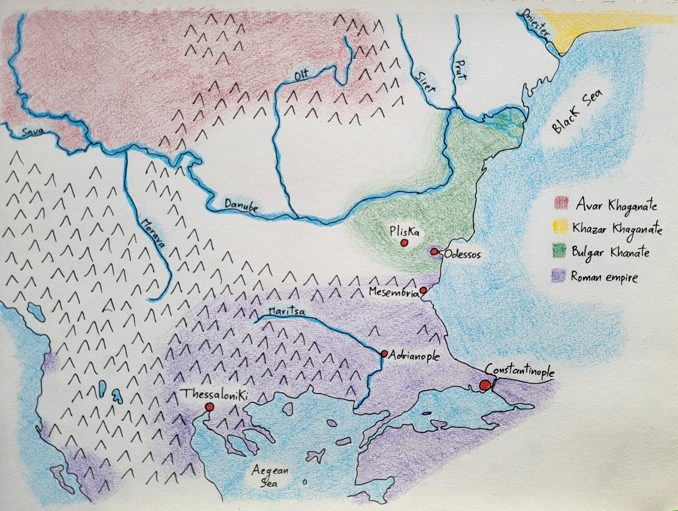
The two sides thereafter signed a pact in 681, which is reflected by the map above. The Roman emperor would pay the Bulgars an annual tribute to keep the peace, as well as recognize their right to settle in Dobrogea. The frontier between their two realms was set at the Balkan Mountains, just north of the Black Sea city of Mesembria.
However, the Romans kept control of the coastal city of Odessos and its hinterland in Dobrogea; though the city was severed from its land connection to the rest of the empire, its port ensured it maintained its links with Constantinople. Meanwhile, the Bulgar leader Asparukh set up his main camp, Pliska, a two-day ride away from the city of Odessos to quickly respond to any threats and also to be near Roman representatives for any potential trade or military negotiations.
Note that, on the map, I haven’t drawn borders as rigid lines; instead, I’ve represented them as diffuse boundaries. The reason is because, especially in this time period and in this region of the world, frontiers weren’t firmly fixed.
We’re no longer in the era of the ancient Roman empire with its limes clearly demarcated by outposts and forts staffed by legionnaires, where the boundary between “empire” and “barbarian” was distinct and enforced. Polities in the seventh-century Balkans didn’t have the resources to closely police their borders. Cities, forts, rivers, and mountains were regarded as boundaries, but in between them, people could move, trade, and interact quite freely, since authorities simply didn’t have the resources or reach to control their actions in these border areas.
And so, on the map, I’ve drawn diffuse frontiers for the Roman empire near Thessaloniki, the Bulgar khanate near Pliska, and the Avar khaganate along the Carpathians as a visual representation of the fluidity of borders.
Leave a Reply